![]()
Since 1998 your premier resource for education in Australia.
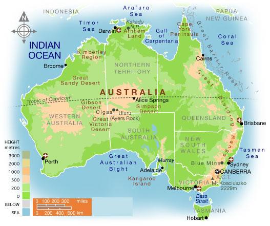 Map of Australia with inclusive statistics on Australia. Australia is officially known as The Commonwealth of Australia and is located in the southern hemisphere The 2008 census estimates the population of Australia is over 21,400,000 people an increase of nearly 1.5 million people since the 2006 census.
The largest city in Australia is Sydney; and the capital of Australia is Canberra. To the south of Australia lies New Zealand.
The area of Australia is comprised of 7,741,220 kilometers or 2,988,902 square miles. The six states of Australia are shown on the map; Queensland, Tasmania, Victoria, Western Australia, New South Wales, and South Australia.
Map of Australia with inclusive statistics on Australia. Australia is officially known as The Commonwealth of Australia and is located in the southern hemisphere The 2008 census estimates the population of Australia is over 21,400,000 people an increase of nearly 1.5 million people since the 2006 census.
The largest city in Australia is Sydney; and the capital of Australia is Canberra. To the south of Australia lies New Zealand.
The area of Australia is comprised of 7,741,220 kilometers or 2,988,902 square miles. The six states of Australia are shown on the map; Queensland, Tasmania, Victoria, Western Australia, New South Wales, and South Australia.
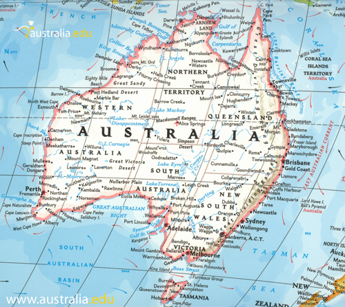 Printable Map of Australia. This High resolution color map of australia should come in handy in planning your travel adventures! Click on the map for a full size printable version.
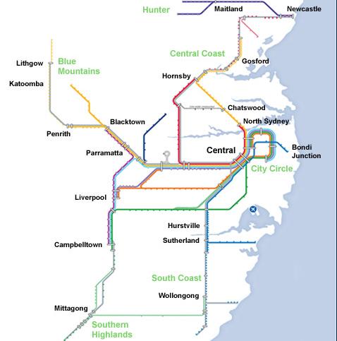 CityRail is a cost effective fast method of transportation for those who will be in or around the Sydney area.For a high quality PDF map of the CityRail network please click HERE Print out this map and ride the rails safely! For more information about the CityRail system please go to the CityRail website.CityRail is a passenger rail service covering the greater Sydney region.
Australia Travel Maps
Arming yourself with maps of various types is a necessity when learning to get around in a new place. International students who come to Australia should have road and transportation maps, as well as maps of the local area. Visitors should also possess a complete map of Australia and its regions. Fortunately, maps are readily available for those who need them.
Types of Maps
A complete map of Australia typically displays the six states and two territories that comprise the country: New South Wales, Queensland, Victoria, Western Australia, South Australia, Tasmania, Australian Capital Territory (ACT), and the Northern Territory.
Transportation maps are handy for newcomers. Australia offers several means of public transportation including bus, rail, air, and ferry. Many of the bus and rail routes coordinate, permitting visitors to easily plan trips and change from rail to bus or bus to rail to get to their destinations. The rail system boasts comfortable, modern long distance and commuter trains. Bus travel is common in Australia. Buses are an economical and practical way to travel through the country. Most metro districts operate efficient bus routes and maps are available both online and at stations. For those who drive, a map of Australia roads and highways is imperative.
Other useful maps include recreation, topographical, and wilderness area maps, beach maps, points of interest maps, local, and historical maps. Back country activities, such as hiking, are extremely popular in parts of Australia and a current map is essential when participating in such pastimes.
Unusual Maps
Along with the traditional map of Australia, transportation, road, highway, and historical maps are some more unusual maps. For example, the Australian government offers a National Public Toilet map on its web site that lets visitors interactively plan a trip that marks every public toilet along the way. The map can be downloaded to a computer or mobile phone. Perhaps a less useful, but nonetheless interesting, map is the Australia Is Big map that overlays a graphic of various countries over the Australian continent to help viewers visualize just how big Australia is.
Map Sources
The government of Australia provides many online mapping services. You can plan your trip, view public transportation routes and connections, download and print maps in PDF format, or download maps to your mobile phone. Most state and territory web sites offer similar services.
Many online trip planning and mapping services sell printed maps, atlases, and other types of maps. Printed maps can also be found at various Australian locations within a locale.
Public bus and rail system web sites are extremely useful sources of maps. Routes can be planned online and maps printed out according to specific instructions.
International students will find many map resources at their educational institution. A map of Australia is just one type they will find. Local, transportation, historical, points of interest, and many other types of maps will be available to them.
Accurate maps will go far to enhance your stay in Australia. Being lost will probably happen on occasion, until you are familiar with the area, but with good maps and common sense, getting lost will be a minor diversion and not a frustrating experience.
Institution Profiles